Journeys take place in the mind as much as they do in physical space, and I have noticed a recurring thought-pattern that unspools every time I travel Interstate 10 between Phoenix and Tucson.
Lots of people are joining me out there: this is the state's most traveled piece of rural asphalt, according to the Arizona Department of Transportation. But the state's busiest freeway is also its most reviled, crossing what many consider swaths of unattractive scrublands and cheerless little offramp villages. "At night and with a six pack," is how one historian friend of mine—a great lover of this state—described his only preferred way to travel I-10.
Nobody writes a poem to this section of expressway, completed in the heyday of the optimism of the Kennedy-Johnson New Frontier between 1961-1971. I have lived in both Phoenix and Tucson off and on and have probably traversed this road more than 800 times, looking at the same sunbaked landmarks and thinking the same reliable thoughts: about old friends, old happenings, old mysteries of my life here. How many others mark their I-10 journeys with a mental libretto of musings on the roadside spectacle?
My sequential reverie doesn't really start until I-10 breaks free from metro Phoenix at the buckle of viaducts that connect to the Santan Freeway and the road bends into the beige expanse of the Gila River Indian Reservation. The 12-story hotel at the Wild Horse Pass Hotel & Casino is the second-to-last tall building a motorist sees until Tucson, and I wonder "wild horse pass?" Is that an actual place name or just a faux-Western branding tool? I imagine the smell of bath soap and linens inside the rooms; the universal aroma of hotels. And I think of Ira Hayes of the Gila River Pima, whose people farmed the Phoenix Valley, in Arizona land, in the geographically fanciful words of Johnny Cash. The shy U.S. Marine was among the crew that raised the U.S. flag on Mount Suribachi at Iwo Jima, and he died consumed with survivor guilt and alcoholism ten years after the war.
You'd hardly know this was an Indian reservation, however, as we pass the infinity loop of Firebird International Raceway and then the earthen bowl of what used to be called Compton Terrace—a big concert venue in the 1980s when DJs on the hard rock radio talked about it constantly and a certain crowd in my high school talked in reverential terms about getting high and drunk after hearing Def Leppard. The venue now lies unsigned and abandoned, looking like a Roman amphitheater on the coast of the Mediterranean. Much of what lies on the edge of I-10, in fact, falls into the category of relics: castoffs of a modern era, their bones bleaching in the sun.
We come up to the perennially jammed off-ramp to Arizona Highway 347, widened to four lanes in 2004 to make room for Maricopa, an explosion of stucco and baked-red tile that qualified it as the fastest-growing city in the country until the foreclosure crisis hollowed it out half-a-decade later. Though the horizontal maze of curving streets cannot be seen from the interstate, I invariably think of the economy founded on cheap housing and mortgage trading; the desert chewed up for families on the move. The detached air-conditioned rancher is Arizona's coal, its steel, its bushels of wheat. Before long, we pass the ruined museum and visitor's center at the exit for the tribal village of Sacaton as we move into a ragged stretch of upper Sonoran hardpan and the first showings of another kind of boom: the swaths of ragged land that have never really recovered from the mania for cotton that swept Arizona in the 1910s. Big chunks of land near the rivers were scraped bare and planted with an extra long staple variety called Pima cotton, a primary component in tires and airplane wings. My great-great grandfather, Franklin La Rue, got caught up in the craze and planted cotton himself on the edge of Phoenix. The demand collapsed after the war and most of the desert fields went fallow. They still look hard-used and wasted.
The road crosses the Gila River, its broad bed gone to dust, but an important psychological line nonetheless. This used to be the border with Mexico before the Gadsden Purchase brought the south part of the state into the U.S. for a Confederate railroad that never got built. Large riverboats used to sail on it before the Coolidge Dam impounded all the water for the cotton farmers. A sign points the way to that sorrowful agribusiness crossroads off to the east; the one that I-10 pretty much murdered when it sucked away the traffic from state highway 87.
The Eisenhower-era bureaucrats knew as much in 1957 when banker and consultant Verne Graves warned in a report that the futuristic freeway would cause Mesa, Florence and Coolidge to "suffer extensively from complete highway relocation." Then-Gov. Paul Fannin told panicked residents—led by a Chevrolet dealer named Brad Sizer—they didn't need to fear an unfavorable decision by the U.S. Bureau of Roads. "I am not interested in seeing how fast we can get people across the state," he told them. "I feel we want people to see what our state has to offer." Today's efficient hypodermic of the freeway makes it clear who won that particular local vs. federal argument. After all, the feds were picking up 94 percent of the bill.
Over a slight rise and we're now into the basin dominated by shabby cotton fields and the sunworn jumble of Casa Grande, where my old Jeep overheated 20 years ago and I had it fixed at a desert garage that seemed ripped from a Cormac McCarthy novel. The left side of the freeway here has been barricaded with a grim concrete wall with a stylized bas-relief diagram of farm furrows radiating away from mountains. This Pinal-themed wall shields a Sam's Club store and a nearby cluster of earth-toned two-bedroom starter homes thrown up en masse by the mega-builder DR Horton—an architectural vernacular as integral to 21st Arizona as the brick townhouse was to Edwardian London. Ordinary life is possible here, the houses announce. I can almost smell the air conditioning and taste the frosted flakes from Sam's Club.

But soon we come upon a dreary counter-example: the highly-visible corpse of the Tanger Factory Outlet mall off Jimmie Kerr Boulevard, which opened in 1991 and started devolving to a husk about 10 years ago when newer outlet malls opened in Phoenix. Few monuments to capitalism look more pathetic than a dead mall. The empty shells of Guess and Izod, as well as the blank cube that was once a Wendy's out front, announce their victimhood.
Just south of here is the convergence of I-10 and I-8, which bends off to the west toward San Diego—the ocean a fantasy abstraction here in the midst of the Sonoran Desert—and in the crotch between the two is a lonely wooden sign for Campground Tierra Buena, i.e. "good land," which seems to have vanished years ago along with so many other failed projects clinging to this midcentury desert arterial. But travelers still need to eat, sleep, defecate and get gas at regular intervals, and very soon we spot the cheap plastic stalks of commerce which grow alongside every freeway in America as reliably as wooden water towers used to mark distances on early railroad lines. Here is the franchise village of Sunland Gin Road: Love's Travel Stop, Motel 6, Arby's. And a curiosity: Blue Beacon Truck Wash—formerly known as Red Baron—which has a second-story tower with strange portholes looking outward. What's in that roasting attic, I wonder. What does it smell like in there? Who thought a medieval-nautical truck wash design was a good idea?
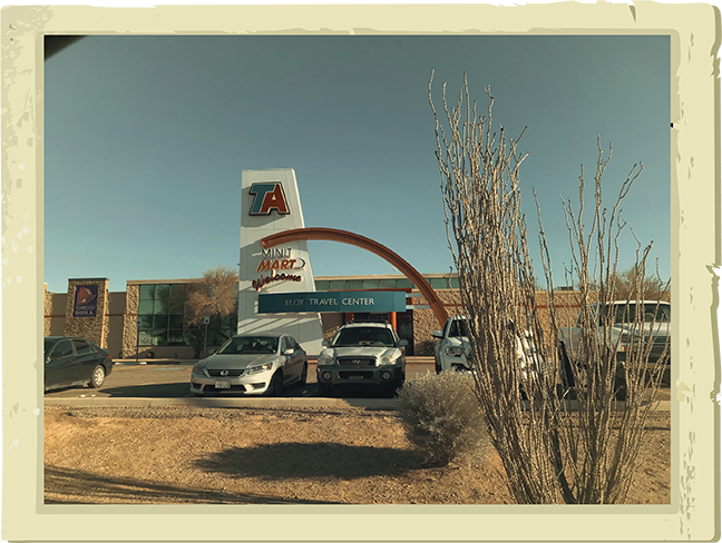
The interstate now takes another bend and we're up against another dreary strip of the quick-life: hamburgers, gas, an RV resort. This one is called—exotically enough—Toltec Road, and it seems to have been the answer of the depressed city of Eloy to the problem posed in 1956 by the route planners who foresaw an economic stink bomb coming to those central Arizona cotton towns bypassed by the ruthless line of the freeway. Eloy had made its life from transportation—its name comes from a 1902 Southern Pacific Railroad acronym for "East Line of Yuma"—and it stood to die by the same forces unless it extended Toltec Road like a straw to suck a little sales tax off the asphalt nipple. The city annexed the north side of the interchange in 1965 and the south side in 1971. And I recall playing basketball in junior high school against a tough team from Eloy; a long-distance trip that then seemed magical.
It isn't long before we pass another dingy I-10 ruin, this one a set of weird-looking birdcages on poles and big truck tires half-buried in the dirt —the lone remnants of an amusement park and "drive-through zoo" called "Family Fun World" that lost its financing in the late 1990s. I can recall a ferocious metal dinosaur that used to stand out there; it's now as extinct as its prehistoric avatars. The big hole there was a clay quarry used for the construction of this very interstate.
The property is within sight, however, of one the verdant patches on the journey: a huge stand of pecan trees, English in their symmetry, which are entirely non-native but always looked shady and inviting. But nearly half of it is gone—removed by the Arizona Department of Transportation for a road-widening project seven years ago. Along with it went nearly the entire town of Picacho, which had been there since the late 1880s when it was a stagecoach stop. The coming of I-10 had been an economic gift in the Space Age, bringing with it two locally owned gas stations and the rectangular Picacho Motel just off the Exit 212 interchange. I remember it as a funky little place with a giant sign with an oval on top that could be seen for miles. Air-conditioning units encased in brown-painted slats hung from the back windows. What did it smell like in those rooms? What little family dramas and road romances happened in there?
I never got to stay at the Picacho Motel. ADOT razed and removed it and 61 other properties in recent years—including the local elementary school, the post office, Marty's Tire and Auto Repair and sacrifices to the same freeway that conjured them into being. I-10 giveth and I-10 taketh away. The businesses are all gone; 37 families had to be relocated. All this happened—a town scrubbed from the earth—without any of the newspapers in Tucson or Phoenix doing a story. That says something dismal either about the currently weakened state of the press or the obscurity of a town like Pichaco, which might be the most-seen and least-visited place in Arizona. My childhood friend Sheldon Folwer and I used to gaze at it with pity from the windows of my mother's car, wondering to ourselves how anybody lived there—and what the kids did for fun. "I'll bet they play some kind of desert game," Sheldon had volunteered, and I imagined an improvised combat scenario with low power BB guns and rocks as weapons. It didn't sound terribly appealing.
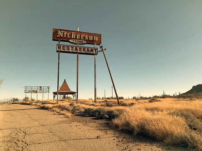
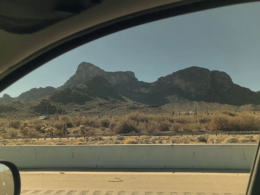
From here you can spot the volcanic saddle of Picacho Peak, whose name is a tortured combination of Spanish and English—literally, "little peak peak"—and the strongest visual symbol of this drive, looking like a frozen sloth rising from a vanished swamp. A little dash of highway commerce is scattered outside the gates of the state park: a Dairy Queen, a sex toy store called Lion's Den, a Shell station. Up a side road are the barely-existent ruins of a Nickerson Farms restaurant that closed in the early 1980s and spent the next three decades falling apart. Once after the roof had collapsed I walked into the shell with a camera and photographed the spindled chaos of all the beams. After a few more years, only the ramada over the driveway was standing. Now even that is gone. As is the giant sign that once had a model of an old-timey truck on top of it—at least a hundred and fifty feet up over the baked plains—advertising a vanished tourist trap named Furrer's that had a museum of vehicles from World War I.
We're almost two-thirds home now, and getting close to an APS power plant which is when—driving here on my way back from college in the late 1980s—I was able to pick up the signal of my hometown pop radio station, KRQ, on the radio of my old Ford and feel a flood of gratitude, familiarity and dread at coming home. The feeling increases as we pass a railroad water tower for the jerkwater stop of Red Rocks, where my pal Sheldon and I—older by then—once drove out to because he had heard of this tiny bar where they served mini-pitchers of beer and were not particular about carding minors. We arrived after 10 p.m. to find the bar closed. Another adventure stopped; story of my youth. Not too much farther and I can see the turnoff for Pinal Air Park and a jumble of tail fins of parked planes, mainly scrapped 747s, looking like the upright necks of pigeons. Guards used to turn visitors away from the gates of this obscure airport back in the Reagan era, though the story eventually leaked out: it was a staging ground for the CIA, which used it to retrofit planes that ferried guns to Nicaragua. Another mystery of I-10, highly visible and extremely concealed all at once.
Up on us is the edge of Marana, a cotton town whose heart was destroyed by this freeway in 1962 just like Picacho had been sacrificed more recently. Perhaps in revenge, Marana became one of the truly greedy exurban jurisdictions of the state during the 1990s, annexing and developing great gobs of empty caliche. Now it has 44,000 people, a burgeoning school district and a whole lot of boxy tract homes. Some of the prior character remains, though—the remnants of Miller's Market in the dot village of Rillito, where I once 30 years ago glimpsed a young girl standing outside near a gaunt older man who looked like her father; a scene right out of a Walker Evans photograph. And nearby the desert gothic kilns and furnaces of the Portland Cement Company, tucked into a grove of eucalyptus trees against a hillside. A truck that used to parked out this way assured passerby Jesus is the Answer, and it was near this spot in the year 1980 when my family was finishing its move from Phoenix to Tucson—a move I hated—and we were transporting a final load of household knickknacks and two reluctant cats in a Volvo station wagon that we passed through a brief squall and came over a viaduct to see a double rainbow shining between us and the green-gray hump of the Santa Catalina Mountains off to the west. My mother describes it as a near-religious moment: a signal to her that a better future awaited in Tucson. I can remember a few caterpillars crawling across the asphalt of I-10 and being not so convinced. This moment turned out to be a kind of hinge: I was about to experience the horrors of new classrooms with strange people in a new town; leaving childhood behind. The rainbow was gone within minutes but the viaduct still there and I am now in middle age, still traveling this most essential of Arizona's rural arteries.
To the right, I can see the Santa Cruz River, which Father Eusebio Kino had used as his own version of I-10, planting missions four hundred years ago under the authority of the King of Spain. To the left, I can see the faraway fold of Pima Canyon, where indigenous rebels against that reign were said to have taken refuge in 1751. Near it flows the alluvial wash called Canyon del Oro, which means "Valley of Gold," and gave its name to my high school. My first real girlfriend lived in a tract home right beside it. Past and present mingle in a carburetor of thought. And here comes Orange Grove Road, an exit from the freeway, and the way that leads home.